Ha Giang Travel Guide: Dong Van, Ma Pi Leng, Villages & Trip Planning
When travellers say “Ha Giang,” they often mean the Loop, but the travel region is bigger than one motorbike circuit. The important decisions are how many mountain-road days you actually want, whether you prefer to ride or be driven, and whether places such as Hoang Su Phi belong in the same trip or should be treated as a separate extension. Start with the core Dong Van–Ma Pi Leng area, then add extra valleys or trekking only when the travel time still makes sense. For the wider northern route, see the Northern Vietnam guide.Ha Giang is a mountain-road destination where route length and overnight stops matter as much as individual viewpoints.
What kind of Ha Giang trip fits you?
Trip style
Time to allow
Best for
Planning note
Classic mountain road route
About 4 days
First-time visitors who want Dong Van, Ma Pi Leng and the core northern scenery
The road time is part of the experience; do not treat each overnight stop as a quick transfer.
Guided rider / private vehicle
3–4 days
Travellers who want the scenery without self-driving mountain roads
Choose the vehicle style around comfort, road conditions and the amount of stopping you want.
Shorter Ha Giang highlights
3 days
Travellers with limited time
Expect a more road-heavy trip. We would rather remove a detour than push every highlight into one day.
Hoang Su Phi / trekking extension
Add 2+ days
Rice terraces, walking and slower rural stays
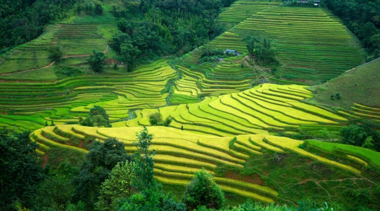
Western Ha Giang is not a simple side trip from the classic Dong Van Loop; treat it as a real extension.
Classic Ha Giang route shape
Hanoi → Ha Giang City → Quan Ba / Yen Minh → Dong Van → Ma Pi Leng / Meo Vac → Ha Giang City → Hanoi
3 days
Possible, but road-heavy. We remove detours before compressing every stop into the same day.
4 days
A balanced first-trip structure because the main passes and overnight stops have more breathing room.
5+ days
Use the extra time for slower villages, Du Gia or a separate western extension rather than simply adding more road.
Self-driving should only be considered when your licence, riding experience and current road conditions make it appropriate; otherwise use a guided rider or private vehicle.
Ha Giang at a glance: province first, Loop second
“Ha Giang” remains the travel name used for this far-northern mountain region and its famous road routes. Following Vietnam’s 2025 provincial reorganisation, the former Ha Giang Province and Tuyen Quang Province were merged into the new Tuyen Quang Province. For trip planning, however, the Ha Giang travel region is still much bigger than one motorbike circuit: the best-known route runs through Quan Ba, Yen Minh, Dong Van and Meo Vac, while western areas such as Hoang Su Phi create a different rice-terrace and trekking journey.When we plan Ha Giang for a first visit, the core question is not “Can we complete the Loop?” but “How many mountain-road days will still feel enjoyable after the Hanoi transfer?” For many travellers, the Dong Van–Ma Pi Leng side gives enough of the dramatic karst scenery. Others are better served by adding village time or a western extension instead of trying to drive every possible road.The classic road circuit is roughly 300–400 km depending on detours and normally needs several days because the distance does not tell the whole story. Mountain roads, photo stops, village visits and weather all slow the pace. A self-drive trip, a guided rider and a private vehicle can cover similar geography but create very different levels of fatigue and flexibility, so we treat transport choice as part of the itinerary design rather than a detail to decide at the end.
Best time to visit Ha Giang
In Ha Giang, weather affects more than the view. Rain, fog and road conditions can change how quickly you move between mountain towns, so we leave more margin in the itinerary than we would for Hanoi or Ninh Binh. Autumn and spring are popular for clearer scenery and seasonal colour; the wetter months can be very green but require more flexibility. In colder months, visibility and temperature become part of the planning, especially on exposed passes.
September to November: Popular for cooler mountain travel, seasonal rice colour and, in some areas, buckwheat flowers. Harvest and bloom timing vary by elevation, weather and year, so we would not promise a particular landscape from the calendar alone.
March to May: Often a comfortable period for mountain travel, with spring growth and flowering in some areas. Road conditions still need to be checked locally because rain, repairs and fog matter more than a seasonal label.
June to August: The mountains are green, but heavier rain can slow road travel and change the safe route for the day. Landslide, runoff and poor visibility are reasons to keep the schedule flexible and follow current local road information.
December to February: Colder weather and fog can make exposed passes feel much harsher than Hanoi. Pack proper layers and allow for reduced visibility rather than assuming every viewpoint or road section will work as planned.
Getting to Ha Giang and where the classic Loop begins
Lung Cu Flag Tower in the Ha Giang travel regionThe main gateway for the classic route is the Ha Giang urban area. From Hanoi, road journeys commonly take about 5–8 hours depending on the service, stops and traffic; there is no direct train or flight connection. The important planning point is what happens after arrival: a long transfer and a full mountain-road day should not be treated as the same block of time.We prefer travellers to begin the mountain route rested rather than step off a long Hanoi transfer and immediately start a full road day. An overnight arrival can work when the transport schedule suits it, but the exact departure time should follow the season, daylight, weather and the first overnight stop. We avoid planning mountain driving after dark because visibility and road conditions become much harder to judge.
How many days do you need in Ha Giang?
The number of days matters more than the exact kilometre count. Three days can cover the main road highlights, but it creates longer riding or driving days and less flexibility for weather. Four days gives the route more breathing room and is the structure we would normally start from for a first visit. With five days or more, you can slow down, add village time or separate a western extension instead of simply adding more hours on the road.We also look at the Hanoi connection. An overnight bus or a long road transfer before the mountain route changes how much energy you have on Day 1, so the first day should not be planned as if you woke up already in Dong Van.
3 days: Core highlights, but expect more time in the vehicle and fewer long stops.
4 days: Better balance for Quan Ba, Dong Van, Ma Pi Leng, Meo Vac and a slower return.
5+ days: Useful if you want hiking, village time or a separate Hoang Su Phi extension.
Top places to see in Ha Giang
Ma Pi Leng PassMost first-time routes still follow the same geographic spine—Quan Ba, Yen Minh, Dong Van and Meo Vac—through the Dong Van Karst Plateau UNESCO Global Geopark, where many of the region’s best-known landscapes sit. You do not need to self-drive to experience them. The choice is how you want to travel between the stops and how much time you want for viewpoints, villages and short walks. If Ha Giang is part of a wider Vietnam trip, plan the mountain section around the transfer days before and after it rather than treating the province as an isolated add-on.
Heaven’s Gate (Quan Ba Pass): After a steep climb out of Ha Giang, the viewpoint opens across the Quan Ba valley and the twin rounded hills below. It is one of the first major landscape stops on the classic road route.
Dong Van: One of the main overnight bases on the classic route, with an old-quarter area, local food and useful access to the roads toward Lung Cu and Ma Pi Leng. It works as a place to slow down rather than just a fuel stop between passes.
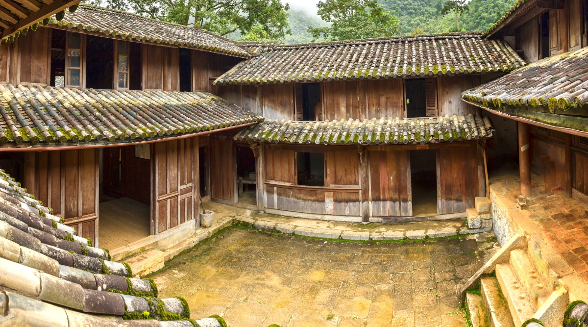
The Vuong family residence is a heritage stop that can be combined with the Dong Van section when time allows.
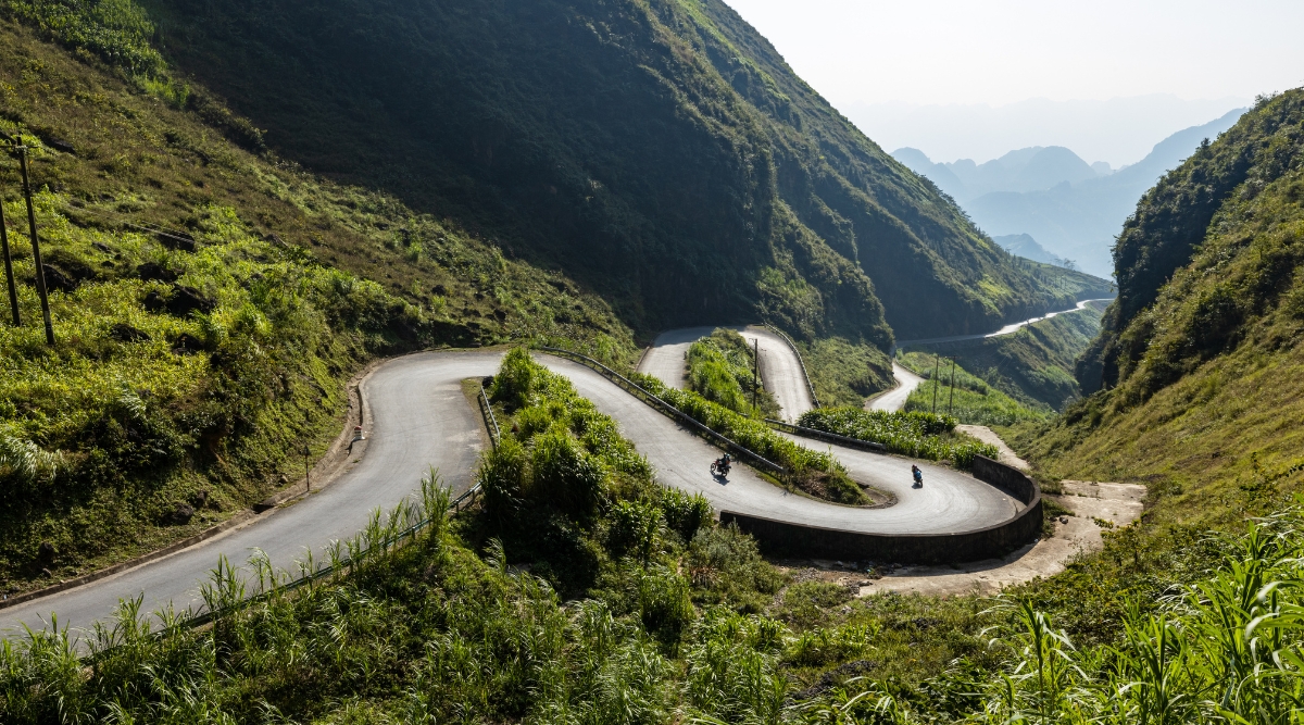
Ma Pi Leng Pass: The road between Dong Van and Meo Vac is one of the core landscape sections of the route, with high viewpoints over the Nho Que River and steep karst terrain. Allow real stopping time and do not turn the pass into a race to the next overnight town.
Du Gia: A valley stop used on some longer route variations. It can give the itinerary a different rural setting from the Dong Van–Meo Vac section, but whether it fits depends on road conditions, the chosen circuit and how much time you have.
Accommodation and homestay culture
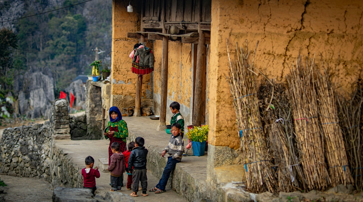
Overnight style changes the road trip more than it first appears. Ha Giang has homestays, guesthouses and small hotels across the main route towns and villages. We choose by location, room privacy, bathroom setup, heating or blankets in colder periods, and how early the next road section needs to start rather than assuming a homestay is automatically the right choice.Village and family-run stays can add useful local context, but the format varies widely. Some offer shared meals and host interaction; others operate more like small guesthouses. We check what is actually included and never treat alcohol, communal dining or access to family life as a required part of an “authentic” Ha Giang stay. If you want more context before visiting villages or markets, see the guide to ethnic groups in Northern Vietnam.Du Gia can work well for travellers who want a quieter overnight stop than Dong Van or Meo Vac, but the experience varies by homestay and route. Mountain nights can become cool even outside winter, so we advise carrying one warm layer rather than relying entirely on the room setup or blankets provided.
How to travel around Ha Giang: guided rider, private vehicle or self-drive
Ha Giang is a road-trip destination, but that does not mean every traveller should drive a motorbike. The mountain roads include steep gradients, tight bends, changing surfaces and weather that can reduce visibility quickly. We choose the travel style around the traveller’s road experience, comfort level and insurance—not around the idea that the Loop “must” be self-driven.
Guided rider / easy rider: Suits travellers who want the open-road experience without controlling the motorbike themselves.
Private car or 4WD: Better when weather protection, luggage, camera equipment, mobility, motion tolerance or simply avoiding long hours on a motorbike matter more than the open-road feel.
Self-drive: Only consider this if you are experienced on mountain roads and legally licensed for the vehicle you plan to use. Do not assume a licence or international permit from your home country is automatically valid in Vietnam. Check current official driving rules and your insurance before renting.
Planning note: If the road itself is not the part of the trip you are excited about, there is no reason to make self-driving the centre of your Ha Giang experience. The scenery, villages and viewpoints can still be the focus when someone else handles the road.
Guided road trip and private-vehicle options
A guided rider or private vehicle changes more than who controls the road. A photographer may want more time at viewpoints; a family may need earlier finishes; a private car gives more protection from cold or rain but changes how often you can stop on narrow road sections.Before departure, make sure the vehicle type, overnight stops and expected daily road time are clear. If Ha Giang is one part of a wider Vietnam itinerary, also check what comes immediately before and after it so several demanding transfer days do not stack together.
Once the mountain section is clear, the Northern Vietnam guide helps compare Ha Giang with Sapa, Ninh Binh and Ha Long before moving into package options.
What to pack for Ha Giang mountain weather and road days
Packing depends on how you are travelling. A guided rider or self-drive setup needs compact luggage that can be secured safely; a private vehicle gives you more room. In every case, mountain weather makes layers and rain protection more important than carrying a long list of extra items.Bring layers, rain protection and footwear suited to the stops you actually plan to make. Card acceptance can be limited outside larger centres, so carry some cash as a backup, but check your accommodation and transport arrangements first instead of carrying an unnecessarily large amount.
Clothing: Temperatures can feel very different between lower valleys and exposed passes, especially once wind, rain or evening temperatures are added. Use adjustable layers and carry rain protection when the forecast warrants it rather than packing for one fixed temperature.
Safety gear: If your itinerary uses a motorbike, confirm the helmet and protective equipment supplied before departure and make sure the fit is appropriate. Do not assume every rental or tour includes the same standard of gear.
Road-day basics: Carry drinking water, basic personal first-aid items and any medication you normally need. Long exposed road sections can be tiring, so the itinerary should include regular stops rather than relying on one long push.
Cash: Keep enough for smaller meals, local purchases and places that do not take cards, while storing it securely and relying on pre-paid accommodation or transport where practical.
Example 4-day road-trip structure through Ha Giang
Four days gives the classic Dong Van–Ma Pi Leng circuit more room than a compressed three-day trip, but the exact roads and overnight stops should stay flexible. We plan each day around daylight, road condition, weather and meaningful stopping time rather than a fixed kilometre target.
Day 1: Ha Giang gateway → Quan Ba / Yen Minh. Use the first mountain day to settle into the road pace, with stops around Bac Sum, Heaven’s Gate and Quan Ba according to weather and daylight.
Day 2: Yen Minh → Dong Van, with Lung Cu or the Vuong family residence added only if the detour still leaves enough time to reach Dong Van comfortably before dark.
Lo Lo Chai is one of the village stops that may be considered when the Lung Cu detour fits the road day.
Day 3: Dong Van → Ma Pi Leng → Meo Vac, then continue toward the chosen overnight stop if road and weather conditions allow. This is a scenery-heavy day, so protect time for viewpoints instead of measuring success by distance.
Day 4: Return toward the Ha Giang gateway with stops chosen around the actual route. Do not tie the same evening to a tight Hanoi connection unless the road-day finish and onward transport have enough buffer.
Tips for riding the Ha Giang Loop safely
Ha Giang is not a route we treat casually. The mountain roads can be narrow, exposed and affected by rain, gravel, fog or larger vehicles. When guests are not experienced and properly licensed riders, we would rather arrange a guided rider or private vehicle than turn the Loop into a self-drive challenge. Whatever the transport style, we avoid planning road sections after dark and build enough stops into the day that fatigue does not become part of the itinerary.
Blind bends: Keep speed low enough to stop within the visible road and follow the guidance of your licensed local driver or guide. Do not rely on sound or another road user anticipating your position.
Larger vehicles: Give buses and trucks extra space on narrow sections and never force a pass where the road edge, visibility or surface leaves little margin.
Road surface: Rain, gravel, roadworks or runoff can change conditions quickly. If you are not an experienced and legally licensed mountain rider, use a guided rider or private vehicle rather than treating difficult road sections as part of the challenge.
Fatigue: Build regular breaks into the road day and finish before tiredness or fading daylight begins to affect judgement. A shorter route is better than completing a planned stop list under poor conditions.
Where Ha Giang fits in a Northern Vietnam trip
Ha Giang works best when you treat the mountain road days as a real part of the itinerary, not as empty transfer time. If you already have Sapa, Ninh Binh and Ha Long Bay in the same week, we would usually remove something before adding Ha Giang. The province deserves enough time for the road, the viewpoints and the overnight stops to feel worthwhile.For a first visit, we would normally start with the Dong Van–Ma Pi Leng route and only add a western extension such as Hoang Su Phi if you have extra days. Use the wider northern route to decide which mountain destinations deserve the available time, especially when Sapa or Ha Long is already part of the trip.
Example longer route: a 21-day Vietnam itinerary gives enough total trip time to combine Ha Giang with several other regions without turning every mountain day into a transfer day. For shorter trips, build Ha Giang as a dedicated northern section rather than forcing it into a fast national itinerary.